Jebel Toubkal: Morocco's Highest Mountain and What It Actually Takes to Reach the Summit
Toubkal: The Honest Account of North Africa’s Highest Mountain
I want to start by addressing the word “easy” as it appears in approximately half the travel articles written about Toubkal. “Toubkal is the highest peak in North Africa and is accessible to fit hikers without technical climbing experience” — this is accurate. “Toubkal is easy” — this is not accurate, and the people who write it have either not done it themselves or have done it under conditions that happened to be unusually favorable and have consequently underestimated what they are describing to people who may encounter less favorable conditions.
Toubkal at 4,167 meters is a serious undertaking. It does not require ropes, ice axes (in summer), or technical climbing skills. It does require reasonable physical fitness, proper footwear, adequate clothing for temperatures that can drop well below zero at the summit even in July, and a clear understanding of what altitude does to a human body that is not acclimatized to it. Two of those four requirements — the clothing and the altitude physiology understanding — are consistently underestimated by people who read the “accessible to fit hikers” description and book a two-day ascent without further preparation.
Let me give you the actual information.
What Is the Standard Route and What Does It Look Like?
The standard route begins from the village of Imlil, approximately 70 kilometers south of Marrakech via Asni. Imlil sits at 1,740 meters — already above most of what visitors to Morocco have been at during their trip — and serves as the base for the Toubkal National Park and the majority of trekking activity in the High Atlas.
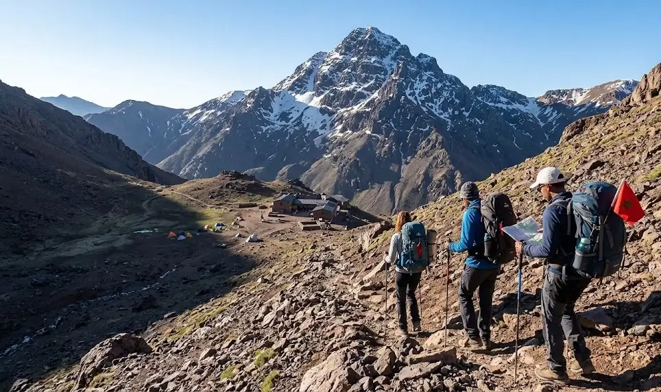
Day one of the standard ascent goes from Imlil to the Toubkal Refuge, which sits at 3,207 meters and takes approximately four to five hours depending on pace. The path climbs steadily through the Mizane valley, past the village of Around at 1,850 meters (where you cross the river and the gradient increases noticeably), through high meadows and increasingly sparse vegetation, and finally up a sustained series of switchbacks to the refuge.
By the time you reach the refuge, most people feel the altitude. Not dramatically — you are not likely to be seriously incapacitated at 3,207 meters if you are healthy and ascended from Imlil at a reasonable pace — but the air is thinner enough that exertion feels more effortful than it did at the start of the day, your appetite may be reduced, and sleeping that night at altitude is, for most people, not as restful as sleeping at sea level. This is normal and not alarming. Drinking more water than you think you need, eating something even if you are not hungry, and descending to sleep at the refuge rather than attempting to push to the summit that evening are all correct responses.
Day two begins early — summit attempts typically start at 5:30 to 6:00 AM, partly to reach the summit before afternoon clouds and wind develop and partly because the snow or scree that covers the upper sections of the mountain is firmer and easier to walk on when it is cold. The ascent from the refuge to the summit takes approximately three hours. It is the physically hardest section: a long, sustained climb on loose scree (in summer) or snow and ice (in winter, where crampons become necessary) with no technical variation, just upward movement on unstable ground at altitude.
What Does Altitude Do and Why Does It Matter on Toubkal?
Altitude sickness — acute mountain sickness, AMS — is the physiological response to reduced atmospheric pressure and lower available oxygen at elevation. Above approximately 2,500 meters, some people begin to experience symptoms: headache (the most common), nausea, fatigue disproportionate to exertion, poor sleep, loss of appetite. Above 3,500 meters — which the Toubkal summit ascent spends considerable time at — the risk increases.
The crucial thing to understand about altitude sickness is that it is not predicted by fitness. Elite athletes get it. Sedentary tourists don’t. The susceptibility is individual and is not reliably predictable in advance. A person who has been to altitude before without symptoms has a reasonable expectation of doing similarly again, but no guarantee.
The practical response: ascend slowly, drink substantially more water than you think necessary (at least three liters during the ascent day), eat consistently even if your appetite is reduced, and be honest with yourself and your guide about how you are feeling. The guides — particularly the experienced mountain guides certified by the Moroccan mountain guide federation (FRMGS) — know the difference between normal altitude fatigue and the beginning of something more serious, and they will descend with you if necessary without making you feel like a failure. This is part of their job. Let them do it.
Who Are the Guides and Why Do You Need One?
The Amazigh guides of the Imlil area have been leading treks in the Toubkal massif for generations — many of them are from families who have been guiding since before the route was formally organized. The federation-certified guides have completed a multi-year training program, speak at minimum Arabic, Tamazight, French, and often English and Spanish, carry first aid certification, and know the mountain in all conditions including those that the standard two-day summer route does not prepare you for.
You can legally ascend Toubkal without a guide. I am telling you this so you know the full information. I am also telling you that the route is marked well enough in summer that navigation is not the reason to hire a guide — though it becomes a very good reason in winter or in poor visibility. The reasons to hire a guide are: local knowledge of conditions, emergency response, cultural introduction to the communities the route passes through, and the simple reality that being on a 4,000-meter mountain with someone who has been there fifty times is a different experience from being on it alone, and almost always a better one.
The Invisible Invitation
The summit at 4,167 meters is cold even in summer — the wind is almost always present, and above 4,000 meters the temperature drops fast when the sun is not directly on you. Sit on the summit for fifteen minutes before you start down, which your legs will thank you for eventually anyway. To the south, the Anti-Atlas and the edge of the pre-Saharan plain are visible on clear days — brown and flat and very far below, another world from where you are standing. To the north, the valleys of the High Atlas spread in every direction, impossibly folded, the villages small and white in the valley bottoms. Your guide will know the name of every valley. Ask him. He has been looking at this view for twenty years and has things to say about it that you will not find in any guidebook. Ask him anyway.
SEO Meta Description: How hard is climbing Jebel Toubkal? The honest guide — standard route, altitude sickness risk, what 4,167 meters feels like, and why the mountain guides of Imlil are essential.
Experience the true heart of Moroccan heritage through its traditions. Join us in preserving these ancestral rituals.
What People Are Saying
No comments yet. Be the first — we'd love to hear from you.
Youssef Amazigh
A Moroccan cultural writer dedicated to documenting the authentic voice, history, and heritage of the Kingdom. Writing from within — to share what truly makes Morocco extraordinary.
Our Mission →